[[TOC]]
This repository hosts detailed information about the 2017 M8.2 Chiapas earthquake in Mexico.
Available information in the folders:
- Impact
- Recording stations
- Ruptrues
- OpenQuake_gmfs
The 2017 Chiapas earthquakestruck at 23:49 CDT on 7 September (local time 04:49) in the Gulf of Tehuantepec off the southern coast of Mexico, near the state of Chiapas. The moment magnitude was estimated to be Mw8.2, with it receiving 8.4 on the Richter Scale. The earthquake caused all of Mexico City to tremble, prompting people to evacuate after the early warning system was triggered. It was the second strongest recorded in the country's history, behind the magnitude 8.6 earthquake in 1787, and the largest recorded globally in 2017, which was felt by 50 million people. The Secretariat of the Interior declared a state of emergency for 122 municipalities in Chiapas. The earthquake affected many states including: Oaxaca, Chiapas, Tabasco, Veracruz, Ciudad de México, Puebla_Tlaxcala, Guerrero, Estado de México_Morelos, Campeche, Yucatán, and Quintana Roo. The earthquake also knocked out electricity for 1.8 million people. An under-construction highway bridge near Mexico City's new international airport collapsed due to the shaking (Wikipedia).- Hundreds of schools were damaged in the Chiapas, Oaxaca, and Mexico City areas. With most of the schools damaged in Chiapas (over 800). Land separation and land fissured were observed at several bridge roads. The Federal Electric Commission reported an estimated 1.85 million affected clients. Based on the Mexico News Daily, about 48 health sector facilities, 29 public buildings, 52 churches and 106 commercial complexes and 11 bridges were severely damaged (Learning_From_Earthquakes).
- This earthquake also had significant impacts on Guatemala: 18.810 were affected, and 2.570 homes were damaged. The most heavily impacted cities were Huehuetenango and San Marcos. 557 people received treatment, 224 were evacuated, 34 were sheltered, 4 injuries, and 2.570 homes were damaged (677 light damage, 887 moderate damage, and 1.006 severe damage). Additional reported damage: 12 sections of roadways, 2 bridges 33 schools, 10 churches and 25 buildings (NOAA).
- Two days after the earthquake occurred, 482 aftershocks were recorded, and fifteen days later, 4.326 aftershocks, whose distribution covers the entire Gulf of Tehuantepec; this amount of events includes all the seismicity detected in the region, whether they can be located or not. Two major aftershocks occurred with magnitudes 5.8 and 6.1; the first appeared on September 8 at 00:24 hrs and was located 72 km southeast of Salina Cruz. The second aftershock of magnitude 6.1 occurred on September 23 at 07:52 hrs in the vicinity of Unión Hidalgo, Oaxaca (see report SSNMX_rep_esp_20170907_Tehuantepec_M82.pdf in References folder).
- The number of reported aftershock varies across references. Additional information is available at Wikipedia, and IRIS.
Figure source: Wikipedia
- In Oaxaca, 3 people were killed during the aftershocks sequence (see report Noticieros_2019.pdf in References folder).
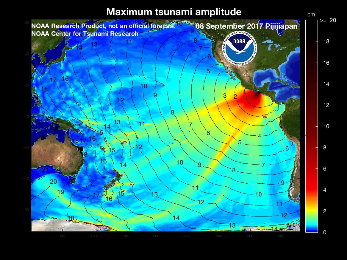
- A tsunami with waves of 1.0 m and higher was generated by the earthquake and was recorded at Salina Cruz. A tsunami wave of 1.75 m was reported in Chiapas. The Pacific Tsunami Warning Center issued a warning for the entire Pacific coast of Central America, also extending south to Ecuador. Wikipedia
- Additional information for tsunami waves available at NOAA
Figure source: NOAA
- Several landslide, rockslide, and landslide settlements on several highways were observed. Several highways suffered from landslides, landslide induced settlements, rockslide, and land separations. Cintalapa-Tuxtla, Arriaga-Ocozocuaitla, Tuxtla-San Cristobal, and Oaxaca-Tehuantepec all suffered from landslides and landslide settlements. Land separation was observed at the Copoya-Tuxtla highway. Rockslide occurred in the area of Tuxtla Guitierrez, Tuxtla Malpaso and Assiaga-Ocozocuautla. The bridge connection Juchitan to Union Hidalgo in Oaxaca state survived but the roads leading up to each side fissured and the supporting walls buckled. In Simojovel, Chiapas, a landslide caused damage to 11 houses. Learning_From_Earthquakes
The estimation of the ground shaking has The folder OpenQuake_gmfs stores the required input files to generate the ground motion fields considering different rupture solutions and conditioning the ground shaking to the recording stations for the event, when available. The figures below present an example of the results, showing the median ground motion fields with and without conditioning the ground shaking for the rupture and ground motion model that indicates the lowest nominal bias.
The information collected for the consequences of the event and the corresponding references is available in the Impact folder. When available, information at different geographical levels is provided considering the building damage, economic losses and human impact.
A summary of the main consequences of the event is available in the earthquake_information.csv file:
| FIELD | DESCRIPTION |
|---|---|
| Year | 2017 |
| Country | Mexico |
| Region | Chiapas |
| Event_Name | Chiapas_2017 |
| Local_Date | 08/09/2017 |
| Local_Time | 23:49:17 |
| Latitude | 14.761 |
| Longitude | -94.103 |
| Depth_(km) | 45.9 |
| Mw | 8.2 |
| Max_Intensity_(MMI) | VII |
| Fault_mechanism | Normal |
| Tectonic_region_type | Subduction Intraslab |
| Fatalities | 61-102 |
| Injured | 250-900 |
| Displaced_Population | 458392 |
| Affected_Population | 1200250-2500000 |
| Affected_Units | nan |
| Damaged_Units | 94027-209863 Units |
| Collapsed_Units | 41000-56504 Units |
| Economic_Losses | 2300-4000 M USD |
| Insured_Losses | 14000-2000 M MXN |
| Induced_Effects | Tsunami, Landslide |
| USGS page | https://earthquake.usgs.gov/earthquakes/eventpage/us2000ahv0/executive |
| Wikipedia page | https://en.wikipedia.org/wiki/2017_Chiapas_earthquake |
We would like to acknowledge the many contributors to the Earthquake Consequence Database.


